

City Know-hows
Our study examines how school accessibility, neighbourhood income, and ethnic composition jointly influence children’s propensity for active school travel in Auckland. We identify culturally specific patterns and spatial clusters, offering evidence to guide targeted policies for more equitable walking commutes.
Share
Target audience
City and school district policymakers, urban planners, transportation authorities, public health and child-safety advocates, and international urban-mobility researchers seeking evidence-based insights for equitable, walkable school-commute solutions.
The problem
Globally, children’s active travel to and from school has declined. This has contributed to rising health concerns. In Auckland, we have observed similar disparities: children’s propensity for active school travel varies markedly across neighbourhoods. While school accessibility affects modal choice, socio-economic status and ethnocultural composition introduce additional barriers that remain poorly understood. As a result, some neighbourhoods exhibit low active travel rates, despite short distances to neighbourhood schools, which undermines equitable access to physical activity and sustainable urban mobility.
What we did and why
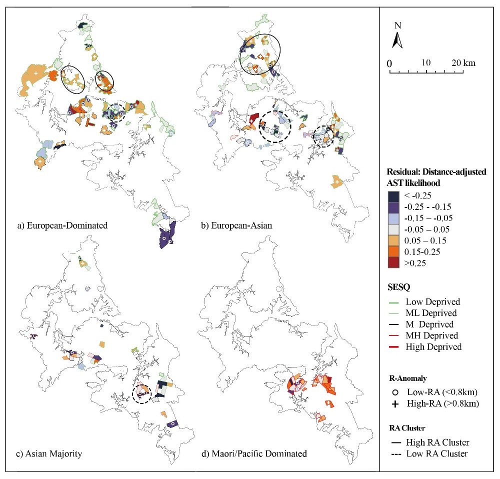
To examine neighbourhood disparities, we integrated 2018 Census data on Active School Travel with built-environment, socio-economic, and ethnicity metrics across 301 SA2-N units in Auckland. Using network-based measures of Nearest School Distance, and using statistical approaches (such as regression modelling, Oaxaca–Blinder decomposition, and spatial mapping), we analysed how socio-cultural and accessibility factors interact to shape Active School Travel. This approach revealed the variable role of Nearest School Distance across different socio-ethnic contexts and identified spatial clusters representing “proactive” and “inhibited” Active School Travel zones.
Our study’s contribution
We find that Nearest School Distance significantly predicts Active School Travel, yet disparities remain across neighbourhoods. Active School Travel variations reflect the underlying socio-economic and ethnic composition. Shorter Nearest School Distance tends to promote higher Active School Travel in minority areas, with Māori/Pacific and Asian-majority neighbourhoods showing sharp declines beyond 0.6 km and 0.8 km, respectively. Conversely, several high-income European and Euro-Asian areas exhibit greater resilience to longer distances (>0.8 km), forming distinct spatial clusters.
Impacts for city policy and practice
We call for integrating socio-demographic data into school and transport planning. Planners should improve route safety in low-Active School Travel neighbourhoods with intermediate distances, informed by local cultural practices and perceptions. School boards and councils can develop community-specific outreach programmes that address ethnocultural concerns, such as safety perceptions and parenting norms, to complement built-environment improvements. Moreover, policy frameworks should require equity assessments to ensure new infrastructure reduces barriers to active travel across all groups.
Further information
Full research article:
[OPEN ACCESS] Examining children’s active school travel at the neighbourhood scale: accessibility and ethno-socioeconomic disparities in Auckland, New Zealand by Xiaoyu Yuan & I-Ting Chuang
Related posts

This study contributes to the broader discourse on urban design for children, offering insights into how cities can create more inclusive, engaging, and health-promoting environments. It supports and adds to existing literature, finding that the alignment of play initiatives with public health goals, and strong collaboration between local government departments are effective in supporting children’s play on the strategic level. It identifies barriers to play in policy, namely budget constraints and deprioritisation of play.

To improve health and wellbeing in cities, municipality employees, urban planners, architects, politicians, citizens, NGOs and funders can benefit by using the collective impact model for working effectively together.

Uninterrupted pedestrian flow is key to walkable, inclusive cities. This study explores how sidewalk conditions, user conflicts, and weather disruptions affect movement. By identifying key qualitative factors, we propose a user-focused method for assessing and enhancing sidewalk Quality of Service (QoS).