

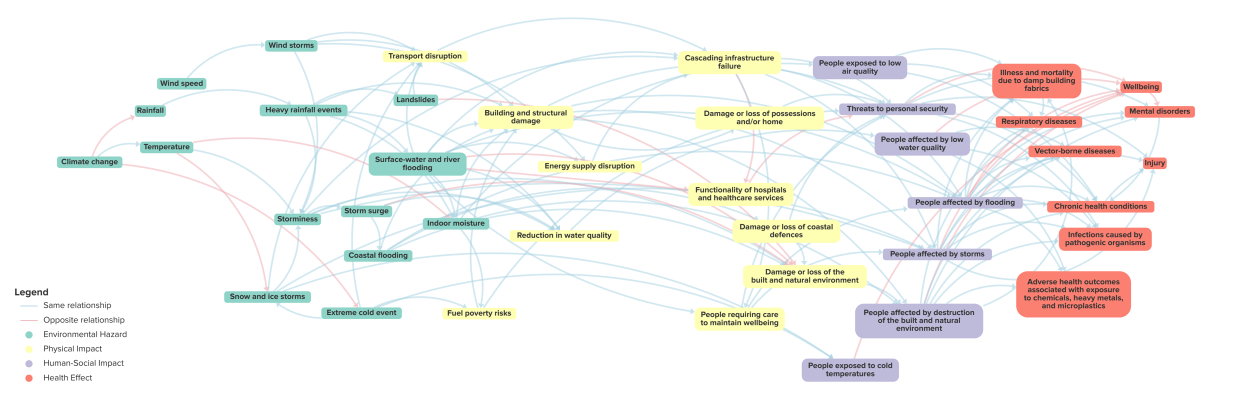
Climate change influences everybody in every sector. New interactive diagrams have been produced to show how and where climate change impacts occur, why they are interconnected, and their consequences on human health and wellbeing. Known as climate impact pathways, they bring together information and data, visualising it in a way that supports a whole-area, multi-agency approach. These diagrams are part of the Local Climate Adaptation Tool (LCAT). 

Share

Target audience

Public sector organisations, urban decision-makers, public health professionals.

The problem

Evidence of the impacts of climate change and potential adaptations to protect the health and well-being of our cities is continually growing. However, this evidence can be difficult to find, shrouded by scientific jargon, or focused only on actions relevant to single sectors. Adaptation action in many countries, including the UK, is lagging due to several barriers faced by local decision-makers, such as a lack of time, funding, and knowledge.

What we did and why

We gathered available evidence on the impacts of climate change and potential adaptations now and in the future in the UK. From this review, we developed systems diagrams that visualise the evidence in an accessible and interactive manner to facilitate the climate change planning process. These diagrams are part of the Local Climate Adaptation Tool (LCAT) which was co-produced with Cornwall Council and a National Stakeholder Group of local decision-makers. 

Our study’s contribution

This study contributes a novel tool and methodology for local decision-makers to engage with during their climate change planning while focusing  on the health of the public. Key features of LCAT and the impact pathways include
• Visualisation by interactive diagram of complex evidence
• Curation of evidence on cross-sector health impacts of climate change and options for adaptation
• Multiple viewing options that layer data from summary through to high level detail
• Accessible language, removing the jargon

Impacts for city policy and practice

The approach we developed promotes multi-agency, multi-sectoral practice, making climate adaptations and health everyone’s business by;
• Developing a whole-place, multi-agency understanding of climate adaptation
• Supporting a health in all policies approach
• Enabling a just and equitable approach to climate adaptation policy and planning

For further information, see;
Local Climate Adaptation Tool (LCAT): This tool shows local areas how local climates will change, health and community impacts in the UK, who will be most vulnerable, and potential adaptation options.
Introduction to Local Climate Adaptation:  This is a guide for local areas on why adaptation matters, who should be involved, case studies from around the UK, and guidance on just and equitable approaches.

Further information

Full research article:

[OPEN ACCESS] Visualising cross-sector climate change impacts on health to support local decision-making by Marissa Rice, Jess Dicken, Timothy Taylor, Rhys Hobbs, Claire Below, Andrew Walton, Ceren Barlas, Simon Kirby & Emma Bland.

Related posts

Informing the design of public greenspaces to optimise wellbeing outcomes for the general population

Our findings highlight how different features including sounds of flowing water, open seating areas, far-reaching views, and a variety of planting (colour, height, texture, scents, attracting wildlife) within a garden influence emotional reactions and perceived restoration. These findings help build a wider picture of the lived experiences of garden users and how their wellbeing may be influenced by specific garden features. We intend our findings to support design guidelines of public greenspaces concerning human wellbeing.

Read More »

Unlocking food access in rural Jordan: Evaluating land use regulations in Annuaymeh village

Through field observations, surveys with the residents, and interviews with decision-maker, we identified key variables that define food access in rural areas in Jordan, mapped access to food services according to the identified variable. and assessed food access in relation to land use regulations. Our work investigated frameworks governing the allocation of food service establishment locations, spatial requirements, integration into city masterplans, equitable distribution of food service types, and pertinent legislative frameworks.

Read More »